
New research, spearheaded by scientists at the University of Colorado Boulder and published in the prestigious journal Nature Geoscience, provides a comprehensive explanation for this astonishing phenomenon. The study pinpointed a critical, often overlooked factor: the unusually flat bedrock lying beneath the glacier. As Hektoria Glacier experienced thinning, this smooth, un-anchored foundation allowed massive sections of ice to lift off the ground simultaneously and begin floating. This sudden delamination from the seabed triggered a highly unusual and catastrophic calving event, where large chunks of ice fractured and broke away into the ocean at an alarming rate.
The implications of these findings extend far beyond Hektoria Glacier itself. This research offers a crucial new lens through which scientists can identify other Antarctic glaciers that might be similarly vulnerable to such swift and dramatic collapse. While Hektoria Glacier is relatively modest by Antarctic standards, covering approximately 115 square miles – roughly the size of Philadelphia – its rapid disintegration serves as a powerful analogue. Should a much larger, more significant glacier, such as the colossal Thwaites or Pine Island glaciers in West Antarctica, undergo a comparable rate of retreat, the consequences for global sea level rise would be profoundly severe, potentially accelerating projections dramatically.
"When we flew over Hektoria in early 2024, I couldn’t believe the vastness of the area that had collapsed," recounted Naomi Ochwat, the lead author of the study and a postdoctoral researcher at CIRES (Cooperative Institute for Research in Environmental Sciences), a partnership between CU Boulder and NOAA. "I had seen the fjord and notable mountain features in the satellite images, but being there in person filled me with astonishment at what had happened. It was a visceral confirmation of the scale of change we were documenting." Her awe underscores the profound impact of witnessing such a rapid transformation in Earth’s icy landscapes firsthand.
The Serendipitous Discovery from Satellite Data
The journey to understanding Hektoria’s collapse began somewhat serendipitously. Ochwat and her team, including CIRES Senior Research Scientist Ted Scambos, a renowned expert in Antarctic glaciology, were initially focused on a different research question. Their primary objective was to investigate the long-term effects of the 2002 collapse of the Larsen B Ice Shelf, a monumental event that reshaped the Antarctic Peninsula and led to significant changes in sea ice dynamics in the region. They were particularly interested in why sea ice continued to detach from a nearby glacier years after the initial ice shelf break.
It was during the routine review of extensive satellite and remote sensing data, a cornerstone of modern glaciology, that Ochwat noticed something entirely unexpected. High-resolution images from various satellite missions revealed that Hektoria Glacier had undergone an astonishingly rapid and dramatic retreat within an incredibly short timeframe. This discovery immediately shifted the research focus, compelling the team to address a more pressing and urgent question: what unique conditions had caused this particular glacier to collapse with such unprecedented speed?
Ice Plain Topography: A Hidden Vulnerability
To understand Hektoria’s rapid retreat, it’s essential to grasp the fundamental dynamics of tidewater glaciers. Many Antarctic glaciers are classified as tidewater glaciers, meaning their termini (ends) flow directly into the ocean. They typically sit on the ocean floor and extend into the sea, where they eventually release icebergs through a process known as calving. The landscape beneath these immense rivers of ice, known as subglacial topography or bathymetry, can vary widely, profoundly influencing their stability and behavior. Some glaciers rest over deep troughs, others over underwater mountains, and still others, like Hektoria, lie across broad, remarkably flat plains.
Hektoria Glacier was found to be situated on what scientists term an "ice plain" – a vast, flat stretch of bedrock submerged below sea level. This specific geological configuration proved to be the Achilles’ heel of the glacier. The team drew upon geological evidence from the past, which revealed that between 15,000 and 19,000 years ago, during periods of significant deglaciation, glaciers positioned over similar ice plains in other parts of the world had retreated at extraordinary speeds, sometimes moving back hundreds of meters per day. This historical insight provided crucial context, helping the researchers interpret the rapid changes they were observing at Hektoria and suggesting a fundamental mechanism at play.
A critical concept in tidewater glacier dynamics is the "grounding line." This is the precise location where a glacier transitions from being firmly grounded on the seabed to floating on the ocean surface. It is a highly sensitive interface, profoundly influenced by both ice thickness and ocean conditions. When a tidewater glacier thins sufficiently, due to either surface melt or basal melt from warm ocean currents, it can lift off the seabed and begin floating. By meticulously analyzing multiple satellite datasets, including interferometric synthetic aperture radar (InSAR), the research team was able to identify several distinct grounding lines at Hektoria. The presence of these multiple, dynamic grounding lines was a tell-tale sign of the underlying ice plain conditions, indicating that large portions of the glacier were only tenuously attached to the bedrock.
A Rare Calving Process Triggered by Oceanic Forcing
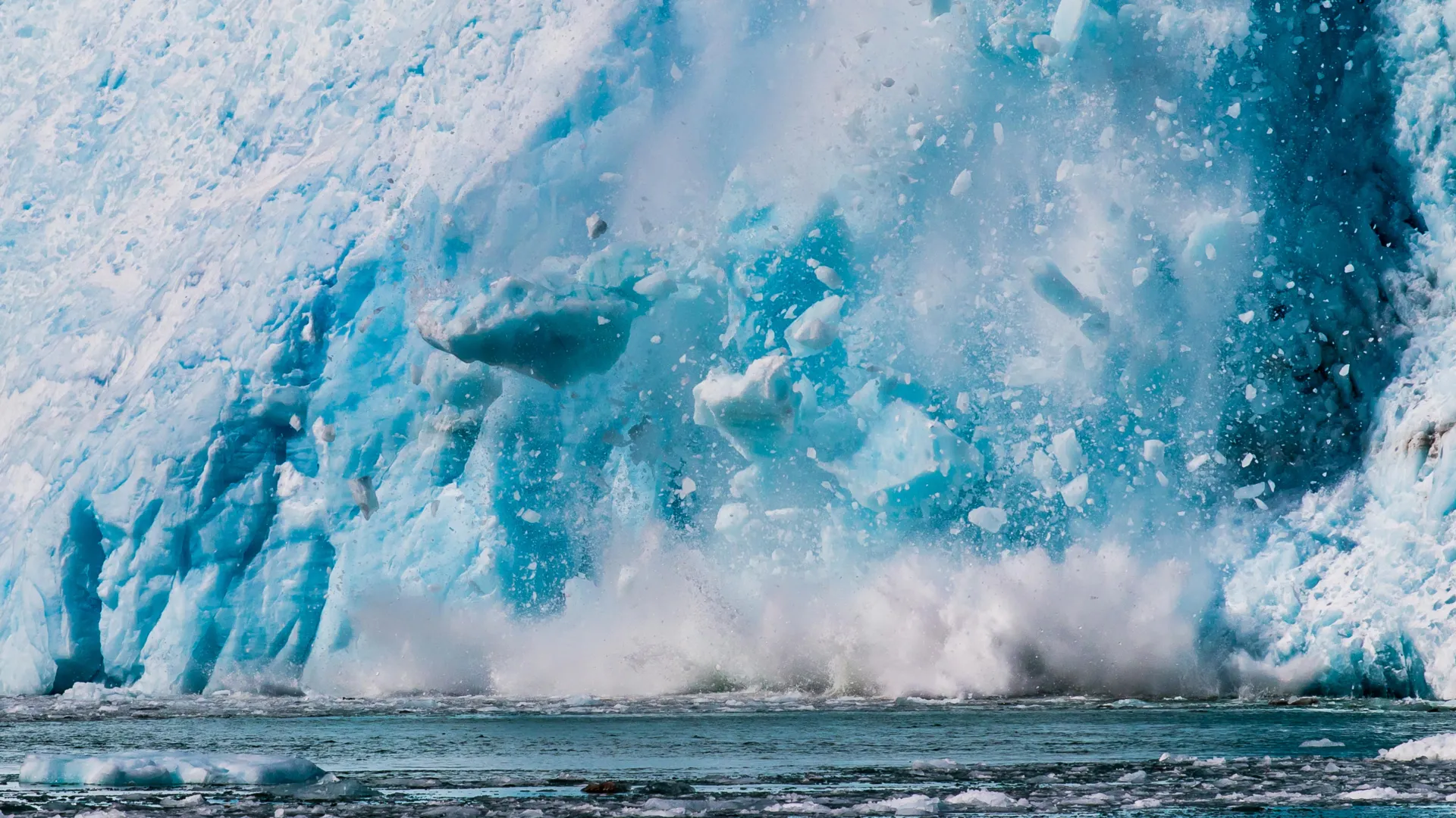
The unique combination of a flat, smooth bed and thinning ice set the stage for Hektoria’s extraordinary retreat. Because the glacier rested on such an un-anchored, flat foundation, vast portions of its ice mass were able to lift off the seabed almost simultaneously. Once afloat, this newly ungrounded ice became immediately exposed to powerful ocean forces, including warmer ocean currents that can melt ice from below, tidal fluctuations, and wave action. This exposure initiated a rapid cascade of destabilizing events.
Cracks, known as crevasses, began to open along the base of the glacier (basal crevasses) as the ice flexed and stretched under the influence of buoyancy and ocean currents. Simultaneously, surface fractures, often caused by the stretching and thinning of the ice, deepened. Crucially, these basal and surface fractures eventually connected, creating pathways for water to penetrate deep into the ice (a process called hydrofracturing). This chain reaction drastically weakened the structural integrity of the glacier, leading to extensive and rapid calving. In a matter of weeks, nearly half of Hektoria Glacier fragmented and disappeared into the Southern Ocean, a scale and speed of ice loss rarely, if ever, observed in modern glaciological records. This process bears similarities to theories of marine ice cliff instability (MICI), where tall ice cliffs, once ungrounded, can become gravitationally unstable and collapse rapidly.
The Power of Satellite Data Fusion
Reconstructing the precise sequence of events during Hektoria’s rapid collapse required an unprecedented level of observational detail. The researchers leveraged a diverse array of satellite missions, combining data from optical satellites like Landsat and Sentinel-2, which provide detailed visual imagery of surface changes, with radar satellites such as Sentinel-1 and TerraSAR-X. Radar instruments are particularly vital in polar regions as they can penetrate cloud cover and operate independently of sunlight, offering continuous monitoring even during the long Antarctic winter. Additionally, altimetry data from missions like ICESat-2 provided crucial measurements of ice surface elevation changes, confirming the thinning.
"If we only had one image every three months, we might not be able to tell you that the glacier lost two and a half kilometers in two days," Ochwat emphasized. "Combining these different satellites, with their varying capabilities and temporal resolutions, allowed us to fill in critical time gaps and confirm with high confidence how quickly the glacier was losing ice. This multi-sensor approach was absolutely key to capturing the full dynamics of the event." This data fusion allowed the team to create a highly detailed, day-by-day timeline of the retreat, revealing the true lightning speed of the collapse.
Glacier Earthquakes: Seismic Confirmation of Ice Loss
Further bolstering their findings, the research team also deployed sophisticated seismic instruments in the vicinity of Hektoria Glacier. These instruments detected a distinct series of "glacier earthquakes" during the period of rapid retreat. Glacier earthquakes are seismic signals generated by various ice dynamics, including the fracturing of ice, the movement of meltwater, or the dramatic events of ice calving.
The specific characteristics of these tremors provided critical corroborating evidence. The seismic signatures confirmed that the glacier had indeed been firmly grounded on bedrock before the rapid lift-off occurred. The shift in seismic patterns as the ice transitioned from grounded to floating provided a direct, physical verification of the presence of an ice plain and the subsequent delamination. Crucially, this seismic data not only verified the underlying mechanism but also unequivocally demonstrated that the ice loss from Hektoria Glacier directly contributed to rising global sea levels, distinguishing it from the melting of floating sea ice which does not directly impact sea level.
Future Vulnerability and Global Implications
The discovery of Hektoria’s rapid retreat and the elucidation of the underlying mechanism have profound implications for future projections of sea level rise. Ice plains, once thought to be relatively stable configurations, have now been identified beneath many other significant Antarctic glaciers, including parts of the massive Thwaites and Pine Island glaciers in West Antarctica, as well as the Totten Glacier in East Antarctica. These are among the largest and most rapidly changing glaciers on the continent, and their stability is critical for global sea levels.
Understanding precisely how these flat, un-anchored beds influence retreat rates will be instrumental in helping scientists better forecast which glaciers might be prone to similar sudden and rapid collapse in the future. This study provides critical new parameters for ice sheet models, enabling them to more accurately simulate the complex interactions between ice, ocean, and bedrock.
"Hektoria’s retreat is a bit of a shock – this kind of lightning-fast retreat really changes what’s possible for other, larger glaciers on the continent," Scambos concluded, his words echoing the gravity of the findings. "If the same conditions set up in some of the other areas, particularly those with vast ice plains, it could greatly speed up sea level rise from the continent, potentially by decades. This study highlights an urgent need for continued, high-resolution monitoring of Antarctica’s vulnerable grounding lines and subglacial topography." The unprecedented speed of Hektoria’s demise serves as a stark reminder that the stability of Earth’s largest ice reservoir may be far more precarious than previously understood, underscoring the critical importance of ongoing research and robust climate action.
