
 By admin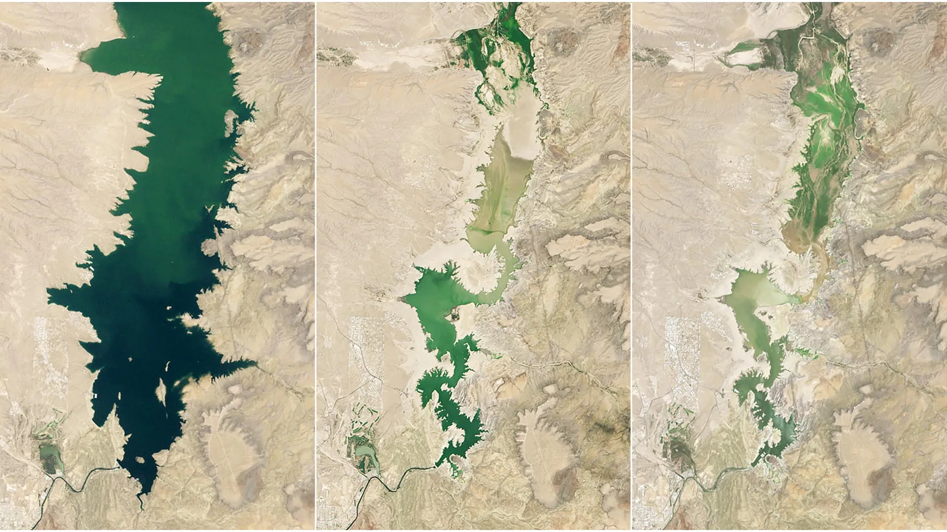
The Rio Grande, often referred to as the lifeblood of the Southwest, has long been a source of both sustenance and contention. Its waters have dictated the ebb and flow of civilizations for millennia, from indigenous communities to Spanish colonial settlements and modern metropolises. The construction of the Elephant Butte Dam, completed in 1916, was a monumental engineering feat designed to tame the capricious river, providing flood control and, crucially, a reliable water supply for irrigation in the vast agricultural valleys of southern New Mexico and west Texas. This dam created Elephant Butte Reservoir, a sprawling lake that not only facilitated farming but also became a vital recreational hub and a critical component of the regional ecosystem. For decades, the reservoir symbolized human triumph over nature, enabling a vibrant agricultural sector that contributes hundreds of millions of dollars annually to the regional economy and supports thousands of jobs directly and indirectly.
However, in recent years, this delicate balance has been severely tested. The Rio Grande basin has been in the grips of a prolonged and extreme drought, a condition exacerbated by the broader "megadrought" impacting the American West, driven by rising temperatures and altered precipitation patterns. This isn’t merely a cyclical dry spell; climate scientists warn that human-induced climate change is intensifying these droughts, making them more frequent, severe, and longer-lasting. Conditions reached a perilous point in 2026 when the river’s headwaters in the southern Rocky Mountains experienced the earliest snowmelt on record. Snowpack in the mountains acts as a natural reservoir, slowly releasing water into rivers throughout the spring and summer. An early melt, driven by warmer temperatures, means less water is available for longer periods, leading to reduced river flows and increased evaporation rates, compounding the water deficit. This premature runoff fundamentally alters the timing and volume of water available for downstream users, intensifying the crisis for agriculture and communities alike.
These compounding factors pushed Elephant Butte Reservoir to an alarming low. On July 27, 2026, the reservoir held a mere 1.4 percent of its total capacity—its lowest level since 1971. To put this into perspective, on June 2, 1994, a period of more abundant precipitation and robust snowpack, the reservoir was nearly full, its vast expanse reflecting a healthy water future. Even during another severe drought, the lake’s annual low on July 8, 2013, saw it at 2.9 percent capacity, still double the level recorded in 2026. This precipitous decline is not merely a statistic; it represents a profound threat to the economic, social, and ecological stability of the entire Rio Grande corridor.
The visible consequences of this extreme decline were stark and unsettling. The receding waters revealed long-submerged debris along the shoreline, relics of a past when the lake was a bustling recreational area. More critically, vast expanses of sediment covered boat ramps at Elephant Butte Lake State Park, rendering them unusable and severely impacting tourism, a significant contributor to local economies. Fishing, boating, and other water-based activities, which typically draw thousands of visitors and inject millions into local businesses, ground to a halt. Beyond the recreational impacts, the exposure of lakebeds and shorelines can lead to increased dust storms, diminished air quality, and altered ecosystems, threatening local wildlife and plant species that depend on the reservoir’s margins.
Despite the grim reality, a glimmer of hope emerged towards the end of July 2026. State officials reported that agricultural water releases, the primary driver of water drawdowns during the growing season, concluded after July 28. This cessation offered the reservoir a chance to slowly begin rising again, albeit marginally, as any remaining trickle of inflow from the Rio Grande would no longer be immediately diverted. However, this temporary reprieve does little to alleviate the broader, existential concerns about the future of water along the Rio Grande. Communities and water users in both New Mexico and Texas depend precariously on a finite supply of both surface water and groundwater throughout the valley. The persistent drought has highlighted the urgent need for innovative and collaborative strategies to manage these increasingly limited supplies, requiring careful and often contentious decisions about how water is stored, allocated, and shared among competing demands.
The challenges are multifaceted, encompassing the needs of a growing population, the demands of a vital agricultural sector, the requirements for environmental flows to sustain riparian ecosystems, and the complexities of inter-state and international water compacts. The Rio Grande Compact of 1938, for instance, dictates how water is shared between Colorado, New Mexico, and Texas, creating a delicate legal framework that becomes intensely strained during periods of scarcity. Further downstream, the 1906 and 1944 treaties with Mexico govern water deliveries across the international border, adding another layer of complexity to an already intricate system. Balancing these legal obligations with the raw reality of diminished supply requires not only political will but also precise, real-time data and advanced scientific understanding.
Enter NASA. Recognizing the critical nature of these water challenges, NASA’s Western Water Action Office (WWAO) has stepped in, leveraging the agency’s unparalleled satellite observation capabilities and scientific expertise to provide water managers with better information for making these crucial decisions. The WWAO’s mission is to translate cutting-edge Earth science data into practical tools and insights that support sustainable water management in the arid West. By applying NASA observations and analytical models, these projects aim to improve the understanding of water availability, forecast future conditions, and support more equitable and efficient resource allocation.
One significant effort supported by the WWAO involved the creation of a sophisticated model that combines various NASA satellite measurements. This model integrates data on factors such as soil moisture, obtained from missions like the Soil Moisture Active Passive (SMAP) satellite, and evapotranspiration, derived from instruments like MODIS and Landsat. Soil moisture is a critical indicator of water availability for plants and runoff potential, while evapotranspiration measures the total water lost from the land surface to the atmosphere through evaporation and plant transpiration. By integrating these complex datasets, the model provides a near-real-time system that significantly enhances and supplements the traditional water allocation methods already employed by entities like the Elephant Butte Irrigation District (EBID). This allows EBID to make more informed, adaptive decisions about when and how much water to release, potentially improving irrigation efficiency, reducing water waste, and extending the available supply during critical periods.
Another groundbreaking project spearheaded by the WWAO combined satellite measurements of water surface heights with observations from drones and ground-based instruments. Satellites like ICESat-2 provide highly precise measurements of elevation changes, including water levels, across vast areas. When integrated with high-resolution data from drones and detailed ground truth measurements, researchers can gain an unprecedented understanding of hydrological dynamics. This combined data was specifically used to examine how groundwater pumping influences the Rio Grande’s surface flow. In many arid regions, surface water and groundwater are intimately connected; excessive pumping of groundwater can directly deplete river flows. Understanding this intricate interplay is vital for effective water rights management, helping officials prevent unsustainable groundwater withdrawals, ensure compliance with existing water rights, and safeguard the long-term health of the river system.
Beyond these specific projects, NASA scientists are also actively participating in a broader federal study focused on the Upper Rio Grande basin. This collaborative initiative involves multiple federal agencies, including the U.S. Geological Survey (USGS), the Bureau of Reclamation, and the National Oceanic and Atmospheric Administration (NOAA). The comprehensive study seeks to better understand the region’s complex water needs, taking into account demographic shifts, agricultural practices, industrial demands, and ecological requirements. Furthermore, it aims to estimate how much water may be reliably available in the future, incorporating various climate change scenarios and advanced hydrological modeling techniques. The ultimate goal is to create robust, data-driven tools and decision support systems that will empower water managers to respond more effectively and adaptively to the challenges posed by a drier future.
The plight of Elephant Butte Reservoir serves as a potent reminder of the fragility of water resources in the face of a changing climate and growing demand. The human ingenuity that transformed the arid landscape, once celebrated by John Glenn, is now called upon to navigate a far more complex and constrained reality. The ongoing efforts by NASA and its partners represent a critical step towards building resilience in the Rio Grande basin. By harnessing the power of satellite technology and scientific research, these initiatives offer the promise of more precise, equitable, and sustainable water management. However, technology alone cannot solve the crisis. It must be coupled with sustained political will, inter-state and international cooperation, and a collective commitment from all water users to conserve, innovate, and adapt, ensuring that the life-giving waters of the Rio Grande can continue to sustain communities and ecosystems for generations to come. The future of the green valley, once a beacon from space, now hinges on the decisions made on the ground.
