
 By admin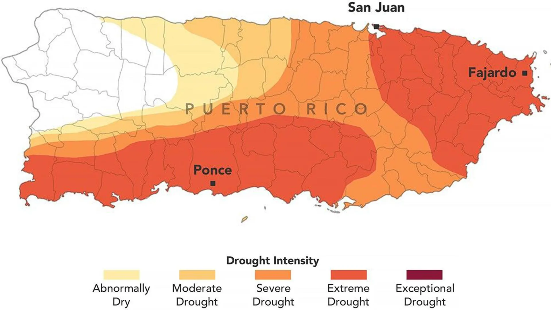
The unfolding crisis, marked by a dramatic shift from a relatively wet early spring to an intensely dry summer, underscores the increasing vulnerability of Caribbean islands to extreme weather patterns. On August 25, 2026, the U.S. Drought Monitor, a crucial collaborative effort, painted a stark picture of the island’s predicament, revealing the severity and geographic extent of the drought. The U.S. government, recognizing the escalating crisis, issued a drought disaster declaration covering more than two dozen cities and towns in late August, following Puerto Rico’s governor’s own state of emergency declaration in late July. This dual response highlighted the urgent need for comprehensive relief and long-term resilience strategies.
A Rapidly Deteriorating Situation: The U.S. Drought Monitor’s Assessment
The U.S. Drought Monitor, a partnership involving the National Drought Mitigation Center at the University of Nebraska-Lincoln, the U.S. Department of Agriculture (USDA), the National Oceanic and Atmospheric Administration (NOAA), and NASA, serves as the authoritative source for drought assessments across the United States and its territories. Its August 25, 2026 map for Puerto Rico showed that approximately three-quarters of the island was experiencing at least moderate drought conditions. More alarmingly, extreme drought zones, depicted in dark orange, had expanded significantly during the preceding week, now covering a staggering 44 percent of the territory, concentrated primarily in the eastern and southwestern parts of the main island.
This rapid deterioration was particularly striking when contrasted with conditions just three months prior. In late May 2026, none of Puerto Rico was classified as being in drought, and less than 20 percent of the territory was considered abnormally dry. The National Integrated Drought Information System (NIDIS) reported that late winter and early spring had actually been wetter than normal across the U.S. Caribbean. However, the meteorological conditions shifted abruptly and dramatically towards severe dryness, setting the stage for the current crisis. This abrupt transition from relative normalcy to widespread extreme drought within a single season is a concerning indicator of potential climate variability and change impacting the region.
NASA’s Crucial Role in Drought Monitoring
NASA’s involvement in the U.S. Drought Monitor project has been long-standing, providing essential Earth observations and scientific expertise. In 2026, this involvement expanded significantly with two NASA scientists joining the small, expert group responsible for producing the weekly drought assessments. David Mocko, a senior research scientist in the Hydrological Sciences Laboratory at NASA’s Goddard Space Flight Center, and Jonathan Case of NASA’s Marshall Space Flight Center, became the first NASA scientists to directly produce these critical weekly maps.
Mocko, who prepared the U.S. Drought Monitor update for August 18, 2026, emphasized the multifaceted nature of the data used. "The effects of the unusually hot and dry conditions were visible across multiple types of satellite and ground-based data used by the U.S. Drought Monitor," Mocko stated. For the recent Puerto Rico updates, particularly vital information included satellite estimates of soil moisture, which provide a direct measure of water availability in the top layers of the soil, crucial for agriculture and ecosystem health. These were complemented by traditional weather measurements, as well as observations of streamflow and well conditions, which offer insights into surface and groundwater reserves.
NASA’s contributions leverage advanced satellite technologies, such as the Gravity Recovery and Climate Experiment (GRACE) Follow-On mission, which measures changes in Earth’s gravity field to monitor large-scale water storage variations, including groundwater. Satellites like the Moderate Resolution Imaging Spectroradiometer (MODIS) provide data on vegetation health and land surface temperature, offering visual indicators of drought stress. The Soil Moisture Active Passive (SMAP) mission provides high-resolution soil moisture data, directly informing drought severity assessments. This integration of space-borne data with ground-based observations creates a robust and comprehensive picture, enabling more accurate and timely drought declarations.
Meteorological Underpinnings: Rainfall Deficits and Soaring Temperatures
The primary driver of the 2026 drought was a severe deficit in precipitation. From mid-May through mid-July, the period typically marking the onset of the wet season, most of Puerto Rico received less than 60 percent of its normal rainfall. Southern and southwestern areas, historically more arid, were hit even harder, recording less than 20 percent of their normal precipitation. This translated to a significant rainfall deficit of 3 to 6 inches (76 to 152 millimeters) across large swathes of the island, a substantial amount for an ecosystem heavily reliant on consistent rainfall.
Compounding the lack of rain were unusually high temperatures. San Juan, the capital city, experienced one of its warmest Julys on record. Elevated temperatures accelerate evaporation from surface water bodies and increase evapotranspiration from plants, effectively drawing moisture out of the soil and further exacerbating dry conditions. This feedback loop intensifies drought, turning what might have been a moderate dry spell into a severe and rapidly expanding crisis. The combination of minimal rainfall and intense heat created an environment where water resources dwindled at an alarming rate.
The impact on natural water systems was immediate and dramatic. River levels plummeted, with streamflow reaching record lows in several waterways, including the Rio Fajardo in northeastern Puerto Rico. These rivers are critical sources for drinking water, irrigation, and ecosystem support. Low river levels directly threaten the capacity of reservoirs that supply communities, leading to immediate concerns about water security.
Profound Impacts: Residents, Farmers, and Infrastructure Under Strain
The strain on Puerto Rico’s water supplies has had far-reaching consequences, affecting virtually every sector of society. For residents, the most immediate and impactful effect has been the implementation of water rationing. Since early August, several municipalities across the island have experienced scheduled water cutoffs, some lasting for extended periods, severely disrupting daily life. News reports detailed the struggles of families adapting to these restrictions, having to store water, alter hygiene routines, and navigate uncertainty about when their supply would return. This rationing not only causes inconvenience but also poses public health risks if residents resort to unsafe alternative water sources or if sanitation suffers.
Beyond the immediate crisis, observers have also pointed to long-standing infrastructure issues as a factor worsening the shortages. Puerto Rico’s aging water distribution system, managed by the Puerto Rico Aqueduct and Sewer Authority (PRASA), has historically been plagued by leaks and inefficiencies. Even with adequate rainfall, significant amounts of treated water are lost before reaching consumers, making the system particularly vulnerable during periods of drought. Investment in upgrading and maintaining this critical infrastructure is paramount to building future resilience.
The agricultural sector, a vital component of Puerto Rico’s economy and food security, has been devastated. Farmers are grappling with parched soils that have disrupted the growth of essential crops. Fruit trees, cacao, banana plants, and coffee plantations, all significant agricultural products for the island, have suffered immensely, leading to substantial crop losses. This not only impacts the livelihoods of thousands of farmers but also has broader implications for the island’s food supply and economy. Ranchers, meanwhile, face dwindling hay supplies for their livestock, necessitating expensive alternative feed sources or, in extreme cases, the difficult decision to cull herds. The economic fallout for these communities is significant, highlighting the need for robust disaster relief and recovery programs.
Emergency Response and Guiding Aid
In response to the escalating crisis, both local and federal governments initiated emergency measures. Puerto Rico’s governor declared a state of emergency in late July, unlocking local resources and enabling expedited actions to address the drought. This declaration was a critical step in mobilizing a coordinated response.
Following this, the U.S. government, specifically the USDA, issued a drought disaster declaration in late August. This federal designation, covering more than two dozen cities and towns, is crucial for channeling emergency assistance to affected communities. The U.S. Drought Monitor maps are instrumental in this process, serving as a "fast track" mechanism for the USDA to issue such designations. These designations unlock a range of federal aid, including low-interest emergency loans, livestock indemnity programs, and other forms of financial and technical assistance designed to help farmers, ranchers, and rural businesses recover from drought-related losses.
The maps, published weekly since 1999, are a cornerstone for federal, state, local, and tribal officials in making informed decisions regarding drought response. They allow for targeted interventions, ensuring that aid and resources are directed to the areas most severely impacted. This scientific, data-driven approach ensures transparency and effectiveness in disaster management.
A Glimpse into the Future: Climate Change and Resilience
The 2026 drought in Puerto Rico serves as a stark reminder of the island’s increasing vulnerability to the impacts of climate change. Scientific consensus, particularly from bodies like the Intergovernmental Panel on Climate Change (IPCC), indicates that climate change is intensifying extreme weather events globally, including more frequent, severe, and prolonged droughts in many regions. The Caribbean, with its unique geographical and climatic characteristics, is particularly susceptible to these shifts. Rising global temperatures contribute to increased evaporation and can alter precipitation patterns, making traditional wet seasons less reliable.
Looking ahead, building long-term resilience against future droughts in Puerto Rico will require a multi-pronged approach. This includes significant investment in modernizing water infrastructure to reduce leaks and improve efficiency. Exploring alternative water sources, such as desalination plants, though costly, may become a necessary consideration for coastal areas. Promoting water conservation practices among residents and businesses, implementing smart irrigation techniques in agriculture, and exploring rainwater harvesting systems are also vital steps. Furthermore, early warning systems, continually refined with advanced satellite data and scientific expertise like that provided by NASA, will be crucial for proactive drought management.
The 2026 drought is more than just a temporary hardship; it is a critical lesson in adaptation and preparedness for Puerto Rico. The coordinated efforts of local governance, federal agencies, and scientific bodies like NASA highlight the collaborative spirit needed to navigate the challenges posed by a changing climate and safeguard the future of the island’s residents and resources.
