
 By admin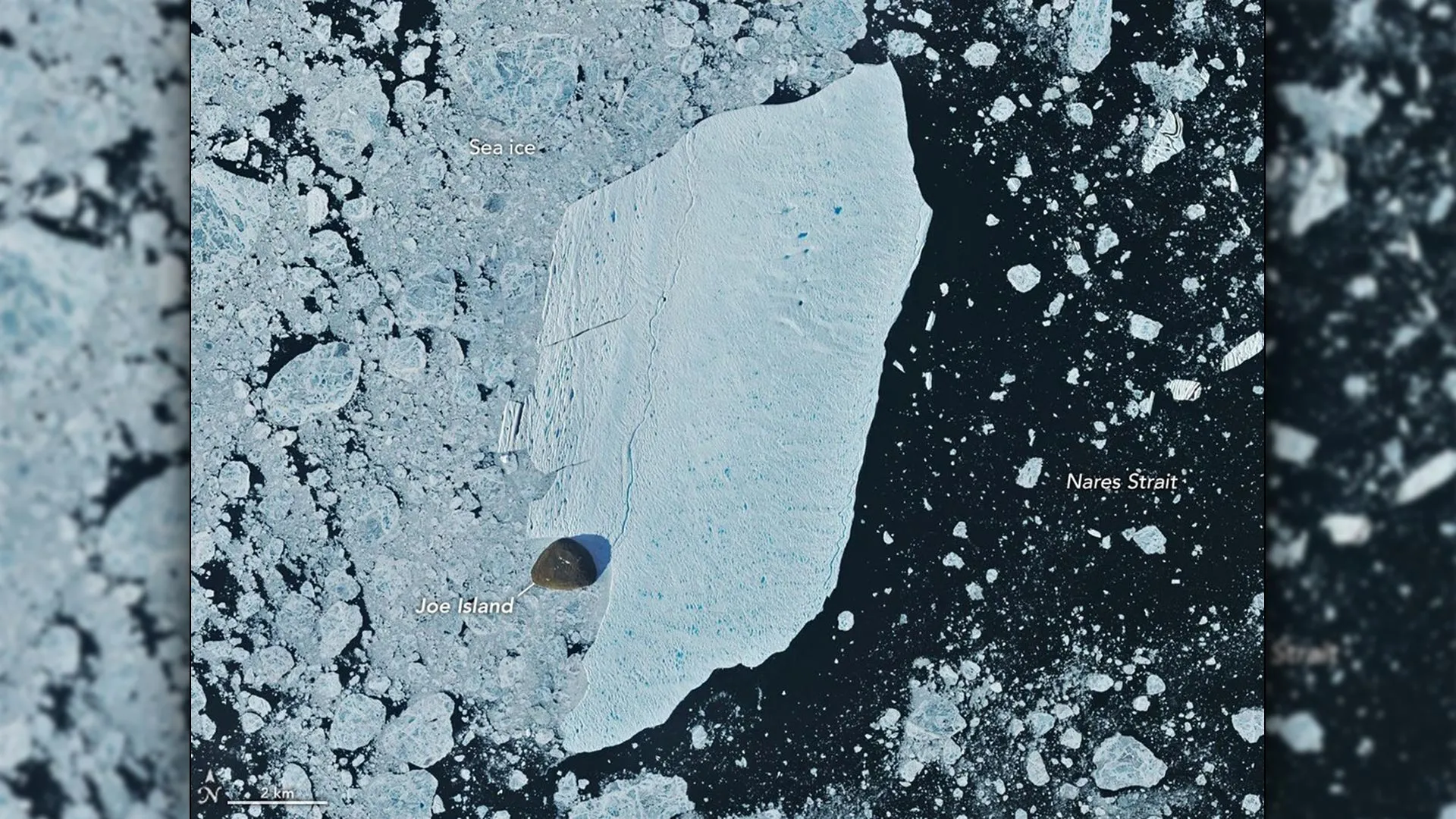
While iceberg calving is a natural and indeed an essential part of the life cycle of outlet glaciers, such as Petermann, scientists meticulously monitor these events. They are not merely isolated spectacles; rather, they serve as critical indicators, providing invaluable clues about the health and longer-term stability of the vast Greenland Ice Sheet. Petermann Glacier stands as one of Greenland’s largest marine-terminating glaciers, extending a significant floating ice tongue far into the fjord. Its crucial role lies in controlling the immense flow of ice from the interior of the Greenland Ice Sheet into the Arctic Ocean. Consequently, any significant changes in its stability, particularly accelerated rates of ice loss, carry profound implications for global sea level rise, making its every movement a subject of intense scientific scrutiny.
Petermann Glacier: A Sentinel of Arctic Change
Situated in one of the most remote and challenging environments on Earth, Petermann Glacier drains approximately 4% of the Greenland Ice Sheet. Unlike many other glaciers, it boasts a substantial floating ice tongue, a vast extension of ice that protrudes into the ocean, typically tens of kilometers long and several hundred meters thick. This floating tongue acts as a buttress, slowing the flow of ice from the grounded portion of the glacier further inland. When ice breaks off this tongue, it’s called calving, and the resulting large, flat-topped bergs are often referred to as "ice islands" due to their characteristic morphology.
Petermann has a well-documented history of producing some of the Arctic’s largest ice islands. Major calving events in recent memory include a 31 square kilometer berg in 2008, followed by a truly colossal event in 2010 that released an ice island just over 250 square kilometers – an area larger than the island of Manhattan. Another significant break occurred in 2012, producing an ice island covering 130 square kilometers. These historical events provide a baseline against which current and future calving can be assessed, allowing scientists to discern whether the frequency or magnitude of these events is changing in ways that suggest increasing instability. The very nature of Petermann’s ice tongue makes it susceptible to these large-scale detachments, as stresses accumulate over time, exacerbated by ocean warming and surface meltwater penetration into crevasses.
The Unfolding Drama of the 2026 Calving
The summer 2026 calving event was first identified on August 4 by Adam Garbo, a diligent doctoral student in glaciology at the University of Ottawa. Leveraging the sophisticated capabilities of imagery from the European Space Agency’s (ESA) Sentinel-1 mission, Garbo detected the nascent stages of the detachment. Sentinel-1, with its all-weather, day-and-night Synthetic Aperture Radar (SAR) capabilities, is particularly adept at piercing through the often cloudy Arctic skies, providing continuous, high-resolution monitoring essential for tracking such dynamic processes. Garbo and an international consortium of researchers have been relying on this and other forms of remote sensing to maintain a vigilant watch over Petermann Glacier, meticulously tracking changes in its floating ice tongue and predicting potential future calving events.
According to the research team, the newly formed ice island, a flat-topped monolith of ancient ice, measured just over 76 square kilometers (approximately 29 square miles) when it finally separated from the glacier’s main body. This made it the largest iceberg to break from Petermann since the 2012 event, which yielded a significantly larger ice island of 130 square kilometers. Comparing it to previous major calving events – 2008 (31 square kilometers) and the record-setting 2010 event (just over 250 square kilometers) – highlights the substantial, though not unprecedented, scale of the 2026 detachment.
Intriguingly, scientists had actually been preparing for an even more massive break. Garbo and his colleagues were closely monitoring one of several major rifts that had been slowly propagating across the ice tongue, appearing poised to eventually sever a much larger section. However, the glacier, in a display of its complex and often unpredictable dynamics, fractured along a different, less anticipated crack. "What surprised us was that the calving instead followed a different fracture, producing a smaller ice island than we had originally anticipated," Garbo explained, underscoring the challenges of precisely predicting the timing and exact geometry of these colossal events. This unexpected fracturing pattern offers valuable insights into the internal stress fields and structural weaknesses within the glacier’s ice tongue, demonstrating that glacier dynamics are not always linear or perfectly predictable, even with advanced monitoring.
As of late August 2026, two other substantial rifts remained prominently visible within Petermann’s ice tongue. Researchers anticipate that these fractures will eventually release new ice islands, estimated to measure roughly 94 square kilometers and 84 square kilometers, respectively. While the exact timing of these future breaks remains uncertain, their presence signifies ongoing structural weakening and hints at a continued phase of dynamic instability for the glacier, ensuring that Petermann will remain a focal point for glaciological research for years to come.
The Iceberg’s Perilous Journey Towards Nares Strait
Following its dramatic separation, the newly minted ice island began its inexorable journey. Glaciologist Mauri Pelto of Nichols College, a veteran observer of glacial change, meticulously tracked the iceberg’s initial movements using a different suite of remote sensing tools: imagery from NASA-USGS Landsat satellites. The Landsat program, with its multi-spectral imaging capabilities, provides crucial optical data, complementing the SAR observations from Sentinel-1. After detaching from the glacier, the berg drifted down Petermann Fjord, a narrow, deep channel that funnels ice directly towards the Nares Strait, a treacherous waterway separating Greenland from Ellesmere Island. During its first week, the iceberg maintained an average speed of about 3 kilometers per day, a stately but steady pace for such a massive object.
Its journey soon brought it to a critical juncture: the point where the fjord meets the Nares Strait. Here, it encountered a small but significant rocky outcrop known as Joe Island (or Joe Ø). This encounter, a pivotal moment in the iceberg’s early life, was vividly captured by the Operational Land Imager (OLI) aboard Landsat 9 on August 23 and August 24. These images provided scientists with an unprecedented, high-resolution view of the interaction between the gargantuan ice island and the relatively diminutive landmass. Joe Island, strategically positioned near the entrance to Petermann Fjord, acts as a natural choke point and often becomes a collision course for many ice islands exiting the glacier. Such collisions are frequently the catalyst for an iceberg’s fragmentation, a process that begins its eventual demise. A notable historical example occurred in 2010 when one of Petermann’s largest ice islands struck Joe Island and subsequently split into two major pieces.
Pelto further noted that icebergs originating from Petermann Glacier are generally characterized by being thinner and inherently more fragile than those produced by other prominent Greenlandic glaciers, such as Jakobshavn Isbræ or Helheim Glacier, which often calve thicker, more robust bergs from deeper within the ice sheet. Furthermore, these Arctic ice islands are considerably thinner than the truly enormous, often multi-year-old icebergs that break away from the vast ice shelves of Antarctica, some of which can be hundreds of meters thick and span thousands of square kilometers. This relative fragility of Petermann’s ice islands makes their survival through collisions all the more remarkable.
A Collision That Defied Expectations
Despite the inherent fragility characteristic of Petermann icebergs, the new ice island displayed surprising resilience, remaining remarkably intact after its forceful interaction with Joe Island. "We were certainly watching closely as it interacted with Joe Island and were impressed that it survived the interaction without further fragmentation," Garbo remarked, highlighting the unexpected outcome. This resilience offers additional data points for models attempting to predict iceberg stability and breakup patterns, suggesting that factors beyond mere thickness, such as internal ice structure or the angle and force of impact, play crucial roles.
At the time of its separation, the ice island was estimated to be less than 150 meters thick, a relatively modest thickness for an iceberg of its surface area. Following its encounter with Joe Island, the powerful combination of prevailing winds and ocean surface currents gradually carried it out of the confines of Petermann Fjord. Satellite observations subsequently confirmed its continued movement, showing it pivoting away from Joe Island and embarking on a southwestward trajectory through the expansive Nares Strait.
However, this intact state is merely a temporary reprieve. Its journey through the Arctic waters is a relentless process of gradual destruction. The constant battering from tides, the relentless push and pull of winds, the erosive power of ocean currents, and the insidious process of melting from both above and below will continue to weaken the iceberg’s structural integrity. Inevitably, this continuous assault will lead to its fracturing into progressively smaller pieces, a process that can take months or even years, depending on its size and the environmental conditions it encounters.
The Far-Reaching Influence of Greenland’s Ice Islands
The ultimate fate of Greenland’s icebergs, particularly the large ice islands from Petermann, is a complex interplay of geography and oceanography. While some thicker icebergs, especially those calved from tidewater glaciers without extensive floating ice shelf extensions, can scrape along the seabed or become grounded within a fjord, ice islands from Petermann typically travel much farther before encountering a similar fate. Many have historically become "grounded" near the coasts of Coburg and Baffin islands, distant landmasses in the Canadian Arctic Archipelago, or have continued their drift into the Labrador Sea.
Garbo and his colleagues emphasized that Petermann ice islands and the numerous fragments they produce during their long journeys can traverse vast distances through Arctic waters. This extensive travel creates significant hazards, posing risks to maritime operations, shipping lanes that are increasingly opening up due to diminishing sea ice, and critical coastal infrastructure in the High Arctic. The sheer scale and unpredictable nature of these drifting giants necessitate continuous monitoring and robust navigational warnings.
Beyond the immediate navigational concerns, these ice islands play another, more subtle but equally profound role in the Arctic Ocean ecosystem. As the colossal blocks of ice slowly melt, they continuously release enormous quantities of freshwater into the surrounding marine environment. This influx of freshwater can alter local salinity levels, influence ocean stratification, and even impact regional ocean circulation patterns, including components of the Atlantic Meridional Overturning Circulation (AMOC). Furthermore, these icebergs can transport sediments, nutrients, and even microbial life, influencing biogeochemical cycles and local marine productivity far beyond the confines of the fjord where the iceberg first broke free. The 2026 Petermann calving event, therefore, is not just a dramatic spectacle of nature but a powerful reminder of the interconnectedness of Earth’s climate system and the ongoing, profound transformations underway in the Arctic, with implications that ripple across the globe.
